

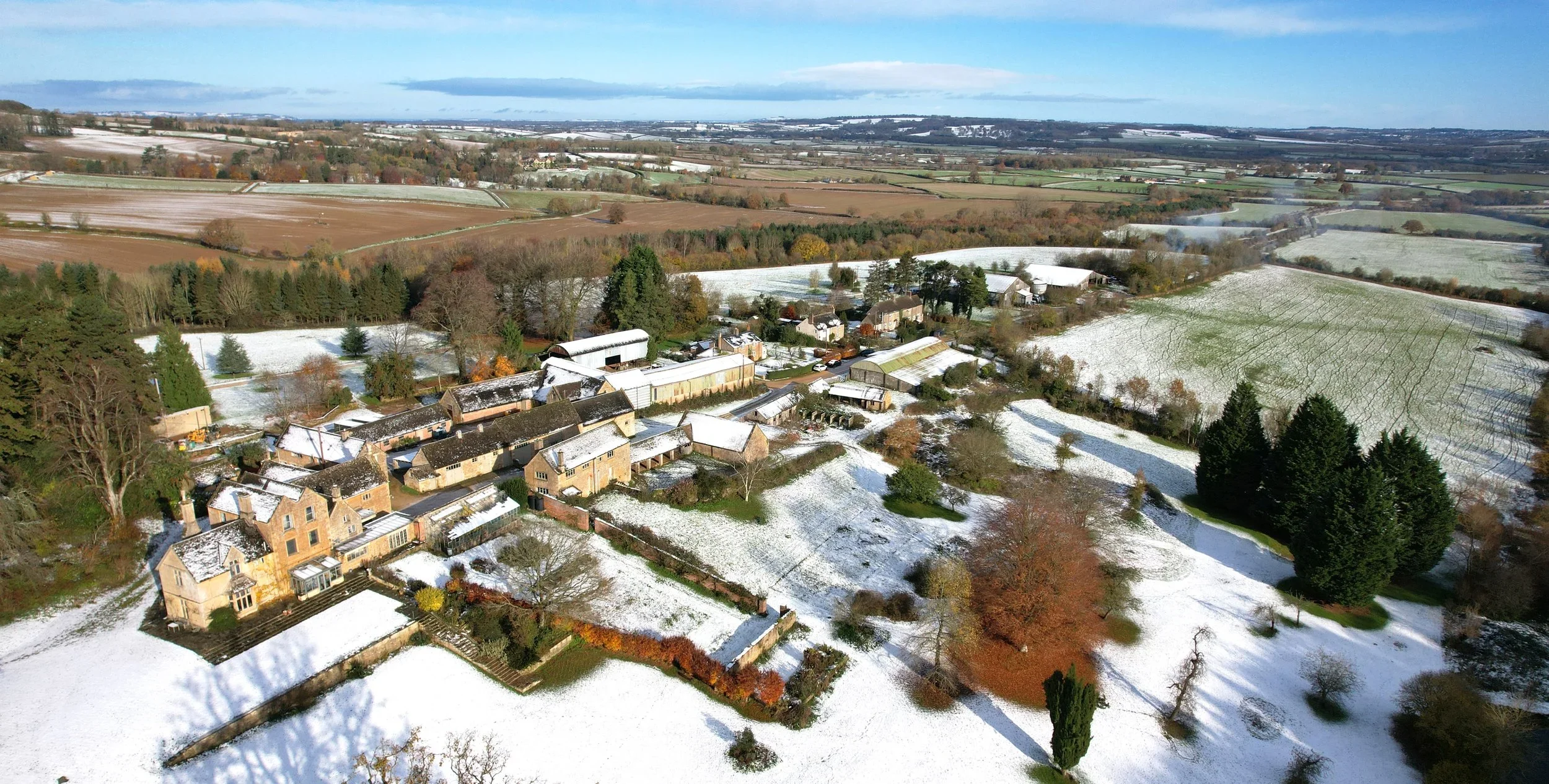
A Cotswolds Estate, at the Point of Changing Hands
What becomes of a property's knowledge when the family who built it moves on
Every estate carries a body of working knowledge that lives only in the people who run it. Where the water mains run. The drain that floods in February. The track filled in twenty years ago that is now a productive field. When an estate changes hands, that knowledge usually walks out of the gate with the outgoing family: the new owners inherit the land, but not the memory of it. This Cotswolds commission was engaged to prevent that loss.
Not a Transition, a Transfer
Anthony arrived ten days before the family's planned departure, and was on the ground for their final three days in residence. Bags were being packed in the rooms upstairs as he sat with them at the kitchen table over flapjacks, plans spread out, working through what they knew of the land. He sorted the keys with them over a gin and tonic in the evening, and walked the gardens to be shown where the family and pet graves lay, recording each. The week was not a transition. It was a transfer.
Three Quarters of It Unrecorded
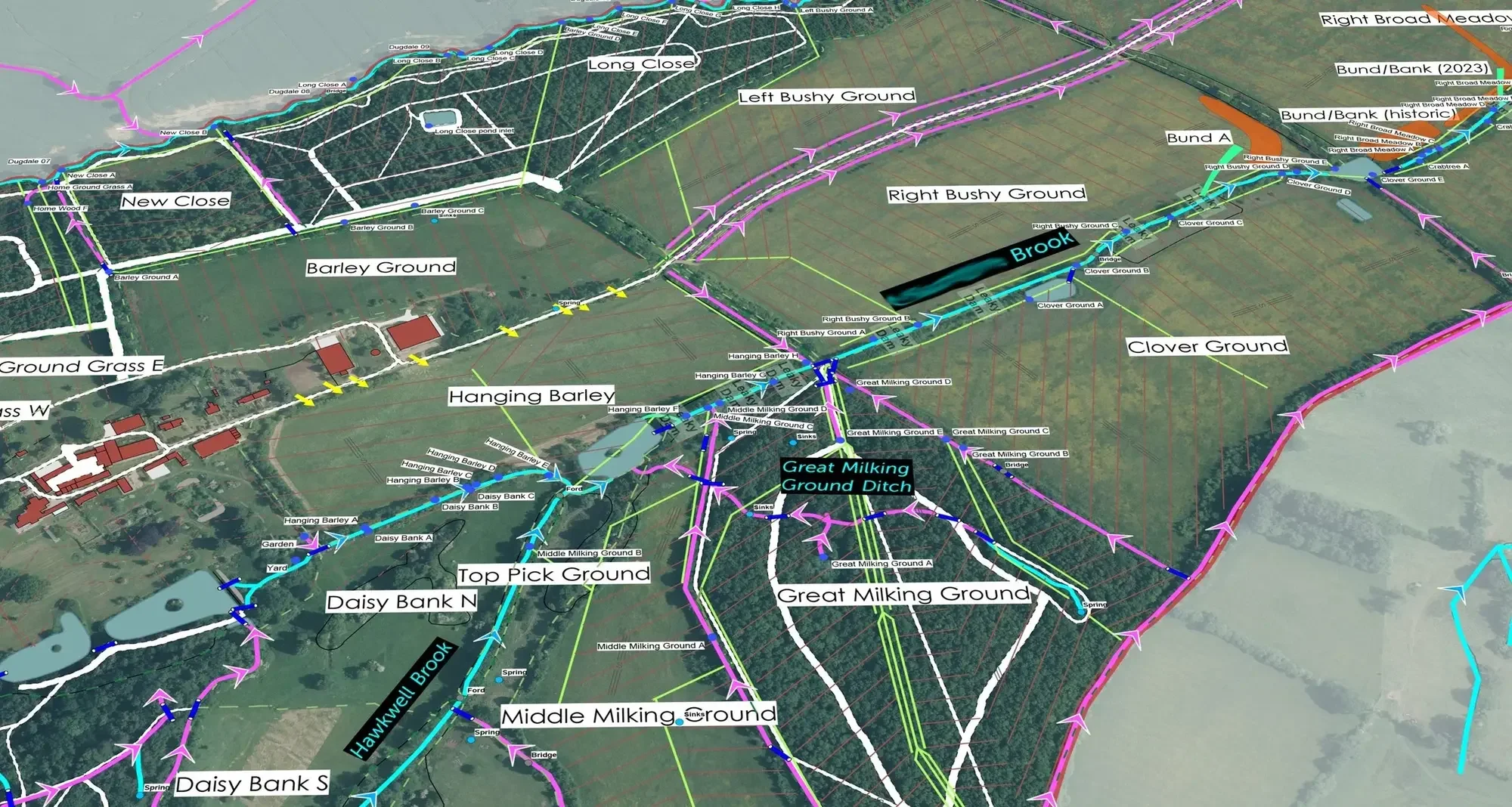
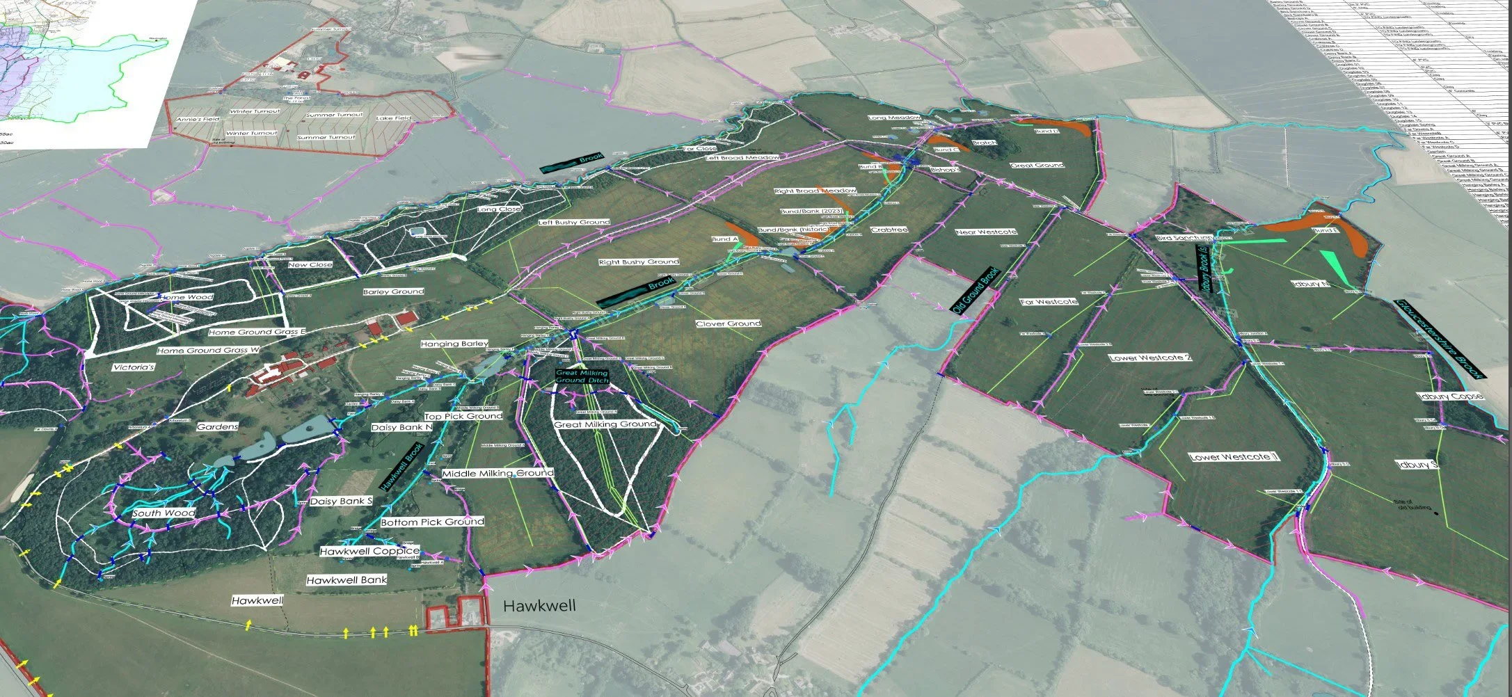
He inherited a fragmented box of dusty plans. It accounted for perhaps a quarter of what was actually on the property; the rest had to be found on the ground. Three mains water networks and three spring-fed systems were mapped in full for the first time, every chamber, valve, stopcock and trough located, accessed and set down in a flow diagram. Anthony lifted every manhole cover on the estate.
A hundred and twenty-five kilometres of clay drain tile, laid in the Victorian agricultural improvements of the nineteenth century, were mapped, and a hundred and twenty-four land-drain outfalls located, several blocked or buried. A 1950s reservoir, still of real value to the estate, was found and recorded. Lost tracks were recovered, and anomalies between deeds, fences and historic ownership resolved.
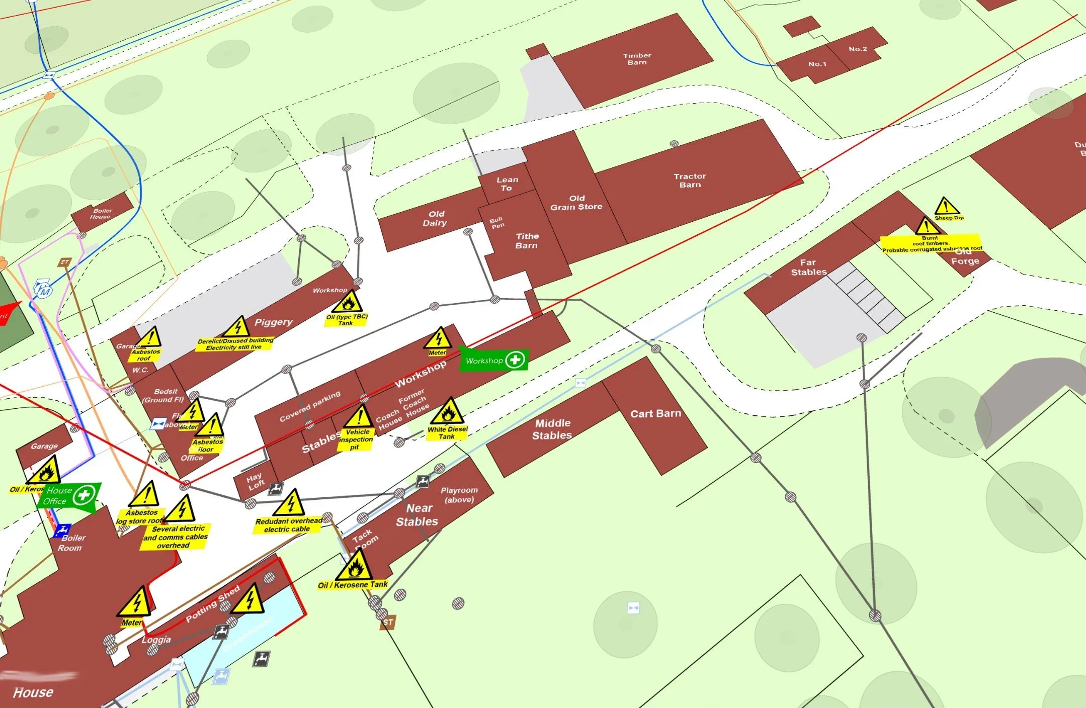
What the Buildings Were Hiding
The buildings gave up their own secrets. An underground Victorian rainwater cistern beneath a historic courtyard, filled with heavy black sludge, was found and cleared. A round brick Victorian septic tank in the garden, unknown to the previous owners and apparently unemptied for decades, was located beside a fallen oak. And a deserted medieval settlement, still legible as earthworks on the ground but absent from the national heritage record, was found and mapped.
Working With the Landscape Architect
Alongside the survey, Anthony worked closely with the estate's landscape architect, Matthew Wigan, whose design for the place is now taking shape. Matthew would ask about the history of an area, when particular trees had been planted, where boundaries had once lain; Anthony brought back what the ground and the conversations were telling him. They walked the estate together, and several elements of the emerging design have been shaped by what the survey uncovered.
“I was introduced to Anthony in mid 2024, and we are both still collaborating on the Gawcombe Estate, in Gloucestershire. As the team landscape architect, I work very closely with Rural Maps. Their comprehensive field work and deep understanding of agricultural practices and rural land use, has been invaluable in informing the strategy for the evolving Estate Masterplan. I have found Anthony personally extremely helpful and obliging. He intuitively understands that each estate and land holding has its own idiosyncrasies, that only reveal themselves under meticulous and close scrutiny. His boundless curiosity generates a granular level of fieldwork, which in turn provides an essential insight into the historic land management, that helps us to safely plan for the future.”
A Living Record
The findings were drawn together into a single twenty-nine-chapter document, covering infrastructure, drainage, buildings, livestock, forestry, ecology, access, history and risk, now in its seventh revision and updated as work is carried out on the ground. All the survey data was uploaded to LandApp, on phone and tablet in the field. The total replacement value of the infrastructure rediscovered and recorded ran beyond £1.5 million.
As the survey concluded, Anthony led a series of tours of the findings for the incoming estate manager, the project manager, the family and the wider team: centuries of layered history walked, named and pointed to in person. He briefed the estate's long-serving site manager at handover, and they have talked regularly since. As things are installed, repaired or changed, they are added to the map.
The property is not named, at the client's preference and as Anthony's default. What a commission reveals about a property stays between the studio and the client unless the client chooses otherwise.
Frequently Asked Questions
Commissioning a knowledge-capture and infrastructure mapping project
-
Without deliberate action, it is largely lost. The working knowledge of an estate lives in the people who run it: the family, the long-serving staff, the retained workers, the retired employees whose memories of the land reach back furthest. When ownership changes, that knowledge is rarely written down in a form the new owners can use. Rural Maps' knowledge-capture commissions exist to prevent that loss.
-
A great deal. On a single Cotswolds commission, infrastructure with a replacement value of more than £1.5 million was rediscovered and mapped, including 125 kilometres of Victorian clay drain tile, 124 land drain outfalls, three mains water networks, three spring-fed systems, a forgotten 1950s reservoir, and lost tracks recovered from beneath modern arable. Roughly three-quarters of what was mapped had never been recorded on any plan.
-
More than people expect. On the Cotswolds commission, Anthony discovered an underground Victorian rainwater cistern filled with heavy black oily sludge beneath a historic courtyard, and a round brick-built Victorian septic tank in the garden that the previous owners did not know existed, apparently unemptied for decades. Each discovery became a known quantity with a location, a condition, and a recommendation.
-
Victorian land drains, lost tracks, forgotten reservoirs? Yes. Much of what makes a country estate run still depends on infrastructure built one or two centuries ago. Recovering and recording it is one of the most valuable services we provide, particularly at the point of an ownership transition.
-
Yes. On the Cotswolds commission, Anthony walked the ground with the new landscape architect throughout the survey, taking him to the places where new discoveries had been made. Findings on the ground informed design decisions on paper.
-
Yes. On the Cotswolds commission, once the infrastructure had been uncovered and recorded, Anthony led a series of tours on the findings for the incoming estate manager, the project manager, the family and the wider team. A map records what was found. The tour walks the new team across the ground itself.
-
Yes. On the Cotswolds commission, Anthony continues to talk regularly with the estate's long-serving site manager, who knows the property in close detail. As things are installed, repaired or changed on the ground, they are added to the map. The written document is now in its seventh revision. Around a fifth of the studio's annual work is returning to maps already made.